Transportation

Map of transportation capital projects dated March 2024

City of Alameda Transportation Projects

Central Avenue: The concept for this project includes a reduction from four to three travel lanes, a center turn lane, bike lanes in the Gold Coast area, a two-way separated bikeway in the west end to Washington Park, street trees/rain gardens and intersection improvements such as roundabouts, curb extensions, pedestrian refuge islands, rectangular rapid flashing beacons and new crosswalks.

Cross Alameda Trail Overall: This project, which is being built in segments, is envisioned as a premiere cross-town, low-stress four-mile bicycling and walking corridor that will connect the west side of the island to the east, from the Seaplane Lagoon at Alameda Point to the Miller-Sweeney (Fruitvale) Bridge.

Clement Avenue: This project consists of a two-way bikeway on the north/estuary side of the street, curb extensions, sidewalk/curb ramp improvements and railroad track removal. It forms a 1.2 mile segment of the Cross Alameda Trail.

Clement Avenue/Tilden Way: This project will use the abandoned railroad right-of-way along Tilden Way and the eastern terminus of Clement Avenue. It will also build the most eastern segment of the 4-mile east-west Cross Alameda Trail, and will directly connect to the Clement Avenue Safety Improvement project, which also is part of the Cross Alameda Trail.

Estuary BridgeAlameda, in partnership with the City of Oakland and others, is working to create a vastly improved estuary crossing for people traveling on foot, wheels and bicycle. A new moveable bicycle/pedestrian bridge is envisioned that would create an easy-to-use, safe and enjoyable connection, filling the significant gap in walking and biking facilities between the West End of Alameda and Oakland.

Fernside Boulevard Traffic Calming and Bikeways Project: This project aims to create a design concept to update Fernside Boulevard from Tilden Way to San Jose Ave. It will also develop an interim concept for Fernside from Tilden Way to High St that can be implemented with pavement resurfacing in the near term.

Grand Street Resurfacing and Improvement Project: The City has identified Grand Street between Shore Line Drive and Encinal Avenue as a high priority for pavement improvements.  The project also is considering safety improvements such as high visibility crosswalks, curb extensions, flashing beacons at Wood School and at the Grand Street/San Antonio Avenue intersection, a protected bike lane for Wood School access/egress, enhancements to bike lanes including buffering where space is available, enhanced bus stops by Shore Line Drive and Wood School, and narrower travel lanes to encourage slower vehicle speeds.  

Lincoln/Marshall/Pacific Avenue Improvement Project: Street design improvements on this corridor from Broadway to Main Street, 3.1 miles with community outreach and draft concept completed in 2022, and Council endorsement of the concept in 2023.

Mecartney Road/Island Drive Improvements: As a key intersection on Bay Farm Island, the Mecartney/Island Improvement Project is in the City’s Capital Improvement Program totaling $300,000 from Measures B/BB monies to fund an analysis and outreach effort so as to improve this busy intersection bringing it up to current best practice standards for safety, adjacent bus stops, path crossings and aesthetics. 

Neighborhood Greenways: Alameda's newest low-stress bicycling and walking facility type, called Neighborhood Greenways, are being designed with community input, starting in 2024. Phase 1 includes converting the Slow Streets segments of Pacific Ave, San Jose/Morton, and Versailles to Neighborhood Greenways by the end of 2025. Almost 10 miles of Greenways are included in the Alameda Active Transportation Plan's 2030 Low Stress Backbone network(PDF, 2MB)

Willie Stargell Avenue: The City is seeking grant funding to make safety improvements to Stargell Avenue between Main and Fifth Streets, including separate walking and bicycling paths in the vacant right-of-way north of the roadway, slowing vehicle speeds, intersection safety and access improvements at the crossings and transit queue jump lanes at either end of the project.

The above projects are funded by a variety of federal, state and local sources including the gasoline tax - SB 1 monies - and the countywide transportation sales tax - Measure BB, which is administered by the Alameda County Transportation Commission.    

Other Transportation Projects (Not led by City)

Doolittle DriveDoolittle Drive in Oakland is expected to be an entry point for coastal flooding at the 100-year flood event.  City staff are working with the key stakeholders - Caltrans, the Port of Oakland, East Bay Regional Park District and the City of Oakland - to seek funding for the project so as to bolster the seawall barrier to keep out bay water.

Encinal Avenue: This Caltrans project restriped and improved State Route 61 (Encinal Avenue) between Sherman Street/Central Avenue and Broadway by resurfacing the street, implementing a road diet from four lanes to two lanes, and adding a center turn lane and bike lanes.  Construction is being completed in 2023. The Caltrans staff contact is Janis Mara at Janis.Mara <at> dot.ca.gov 

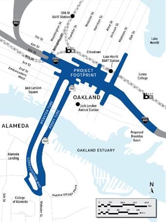
Oakland Alameda Access Project: This $152 million project, led by the Alameda County Transportation Commission (Alameda CTC), includes improvements to the Jackson Street on-ramp and off-ramp, Sixth Street, Webster Tube entrance from 5th & Broadway,  adjacent streets in Alameda and Oakland, and a new (4 foot) pathway for people walking and biking in the Webster Tube plus the elimination of the Broadway off-ramp. The City of Alameda actively engaged with Alameda CTC and the City of Oakland on the project scoping, planning, environmental and design phases. Construction plans will be finalized in 2024, and the project is expected to begin construction in Spring 2025 and be completed by Fall 2027. This September 2023 Alameda CTC presentation provides a helpful overview of the project design, schedule, and construction phasing:

Presentation(PDF, 4MB)

The City of Alameda’s Transportation Commission considered this project at their October 28, 2020 meeting, and the City Council at its November 17, 2020 meeting. The City submitted comments on the draft Environmental Document(PDF, 186KB) in December 2020.
Map.png

Get Around Alameda - click here for bus, ferry, bicycling, walking and driving information!

Alameda for Independent Mobility (AIM): A pilot program for low-income City of Alameda residents who are ages 70+ OR 18 years+ and enrolled in East Bay Paratransit. This program is a concierge service that provides up to six, one way rides per month using Uber or Lyft. Click here for more information.

Alameda Transportation Management Association (Alameda TMA): A separate non-profit organization that is in charge of implementing transportation programs for employers and residents who contribute to the organization. Click Here

Bicycle Safety Classes: Free classes and workshops are offered in Alameda, neighboring cities and online for all ages by Bike East Bay. The City funds additional classes in Alameda, also listed on the same web page, to support our goals for safe bicycling and driving.

Bike Festival: Annual free, fun event promoting bicycling safety and education for people of all ages. Event page

Bikeshare: Alameda was the first East Bay city with a public dock-less bike share system. Click here to learn more. 

Bike Valet Parking at Fruitvale BART Station: Secure parking can be found at the Fruitvale Bike Station, featuring free, secure bike storage and a full-service bike repair shop. 

Carshare: Starting May 2018, up to 35 Gig Car Share vehicles were launched on the main island of Alameda, ready to be used for one-way trips between the main island of Alameda, core East Bay communities, and five San Francisco locations.  Getaround has vehicles in four dedicated spaces in Alameda as well as peer-to-peer carshare in Alameda.  For adults, order on line or at Walgreens. 

Clipper Cards:  Clipper is the all-in-one transit card for the Bay Area that makes it easier to ride transit.  You can add value to your card as you go, or for added convenience, you can set up Autoload, which automatically reloads your card whenever your pass expires or your cash value balance falls below $10.  Youth discounts and discounts for seniors/people with disabilities also are available.

Curb Management: Parking and curb management as part of the transportation system. Click here.

Electric Vehicle + Bicycle Adoption: Alameda is striving for a cleaner, zero-greenhouse gas emission future.  With Alameda Municipal Power (AMP), the city-owned electric utility, providing 100 percent clean energy as of 2020, transportation emissions represent over 70 percent of Alameda's greenhouse gas emissions. The city's goal is to reduce greenhouse gas emissions by 50 percent by 2030, which is in the Climate Action and Resiliency Plan Click here to learn more.

FasTrak: FasTrak or new toll tag for I-880 Express Lanes: online or at Walgreens (except not Park Street location) and then register online

Guaranteed Ride Home Program: For Alameda County employees using transit or walking, bicycling, carpooling or vanpooling to work, you can register for the free Guaranteed Ride Home program. The program guarantees a free ride home for employees working in the event of unexpected circumstances such as illness, family crisis or unscheduled overtime.

Safe Routes to School: School routes, Countywide SR2S information and school maps are provided here, under "Getting to School."

Slow Streets Alameda: In response to the COVID-19 emergency, the City launched a Slow Streets program in April 2020 to provide more space for people to walk and bike with the required physical distancing. In 2024, these Slow Streets will begin transitioning to Neighborhood Greenways, as described on the Slow Streets web page.

Street Trees and Tree Removal: The City of Alameda maintains an urban forest of street trees.  For tree removal, staff is available to assist.

Traffic Calming and Traffic Safety: The City has many ongoing projects and programs to calm traffic and improve traffic safety. Learn about the overall program here.

Vision Zero: Traffic safety program aimed at eliminating traffic deaths and life-changing injuries. Click here.

Water ShuttleThe Oakland Alameda Water Shuttle is a new free service connecting Jack London Square (in Oakland) and Alameda Landing (in west Alameda) across the Oakland Estuary. Launched in July 2024, this two-year pilot developed and operated by a partnership of public and private organizations and agencies, including the City of Alameda, will start as a limited service, with the opportunity to grow over time.

The City's transportation planning and programming funding is largely supported by Alameda County's Measure BB.

Roundabouts Planning

Roundabouts reduce the types of crashes where people are seriously hurt or killed by up to 78 percent when compared to signalized intersections.  Roundabouts result in lower vehicle speeds around the roundabout.  Crashes that occur will be less severe because of this reduced speed and the more “sideswipe” nature of crashes.  Pedestrians are generally safer at roundabouts, and are faced with simpler decisions at a time. Videos and presentations on roundabouts are as follows:

Due to the benefits of modern roundabouts, the City hired Kittelson & Associates to provide an educational presentation on roundabouts(PDF, 2MB), to identify top locations for potential roundabouts, to peer review the proposed Central Avenue roundabouts, and to add policies related to roundabouts in the General Plan update.  The first amendment of the agreement included an evaluation of the Mecartney Road/Island Drive intersection for a potential roundabout, and a screening of roundabouts in the Lincoln Avenue/Marshall Way/Pacific Avenue corridor.  The second and third amendments included a citywide screening for roundabouts(PDF, 1MB) as well as initiation of the Clement Avenue/Tilden Way project.  The results of a citywide roundabout analysis was discussed at the May 2022 Transportation Commission.

Funding for these plans is largely supported by Alameda County's Measure B and BB.

Other Transportation Planning Efforts (Not led by City)

Link21

The City of Alameda supports a BART station in Alameda as part of Link21 - the new regional rail and transbay rail crossing project between San Francisco and Oakland.  Link21 is sponsored by the San Francisco Bay Area Rapid Transit District (BART) and the Capitol Corridor Joint Powers Authority (Capitol Corridor) to transform the passenger rail network serving the 21-county Northern California Megaregion, which includes the greater San Francisco Bay Area, the Monterey Bay area, the Sacramento area, and the Northern San Joaquin Valley.  At the core of Link21 is a new transbay rail crossing project between Oakland and San Francisco.  In addition to the new transbay rail crossing, Link21 will include other projects to improve the reliability, frequency, capacity and hours of service for Northern California's rail network.  Link21 project information is available on the webpage here.  In December 2022, a UC Berkeley Masters Transportation Studio student group analyzed potential locations for a rail station in Alameda with results here, and shows the three potential locations as Alameda Point, College of Alameda area and South Shore area.

Contact Us: transportation@alamedaca.gov  

Project updates: To receive emails with updates on specific transportation projects, or transportation in general, subscribe here

Meetings: To participate in transportation-related meetings or workshops, please refer to "Upcoming Events" tab on this web page, or the City's Event Calendar

Resolving Issues: To submit service requests and reporting issues: SeeClickFix. You also can download the mobile app.

Receive Safety Alerts: To receive text messages, emails or phone messages regarding urgent or emergency incidents: AC Alert

Transportation Commission: To learn about how to take part, see the Transportation Commission web page.

Consider participating in a Transportation Commission meeting or becoming a commissioner: Click Here

Lisa Foster
Transportation Planning Manager
510-747-6833
lfoster@alamedaca.gov

Key Projects/Programs: Vision Zero Traffic Safety; Parking Policy & Planning; Car Share; Transportation Commission

Rochelle Wheeler
Senior Transportation Coordinator
510-747-7442
rwheeler@alamedaca.gov

Key Projects/Programs: Active Transportation Plan implementation; Neighborhood Greenways; Bike Parking; West End Estuary Crossings (Water Shuttle and Estuary Bridge)

Susie Hufstader
Senior Transportation Coordinator
shufstader@alamedaca.gov

Gail Payne
Project Manager (part time to transportation)
510-747-6892
gpayne@alamedaca.gov

Key Projects/Programs: Adaptation Sea Level Rise; Corridor Improvement Projects; Smart City Master Plan

Liz Escobar

Paratransit Coordinator
Phone: 510-747-7513
Email: CityParatransit@alamedaca.gov

Key Program: Paratransit Program